General Questions
- What is EFAS and its main purpose?
- Why and when was EFAS founded?
- Who is responsible for EFAS and who executes the service?
How does EFAS work?
- What information does EFAS provide?
- What data does EFAS use to produce its forecasts?
- Who designed the hydrological model used in EFAS?
- Does EFAS forecast floods only for large rivers?
- Are EFAS forecasts precise and reliable?
- How is EFAS further developed and improved?
- Is EFAS fully operational?
- Who can register to EFAS?
- Is EFAS free of charge?
- Does EFAS provide training to its users?
How do EFAS Notifications work?
- When, and on which basis does EFAS issue flood notifications?
- Why do EFAS notifications only refer to a return period of 5 years or 20 years to measure severity? Would it not be necessary to go beyond (e.g. 100-year return period) to better understand the exceptional nature of rainfall?
- What type of information is contained in EFAS flood notifications?
- Why are EFAS notification so short?
- What additional information can be provided once the notification has been received? Where to search for it?
- What are the usual next steps after EFAS has sent a flood notification?
- Who receives EFAS flood notifications?
- Are EFAS flood notifications available to the public?
- Are EFAS Flood Notifications without any obligation?
- Does EFAS monitor what is being done after the notification has been issued?
- Does EFAS request acknowledgement of receipt from the relevant authorities once a notification has been received?
Other Questions
- What other services relevant for flood risk management are available under CEMS?
- Do satellite images help in forecasting floods or do they only serve coordination efforts?
- Who is responsible for preventing, preparing and responding to natural and man-made disasters in EU Member States?
- On what basis is the European Commission supporting Member States in the field of early warning?
General Questions
What is EFAS and its main purpose?
The European Flood Awareness Systems (EFAS) of the Copernicus Emergency Management Service (CEMS) is the first operational, pan-European flood forecasting and monitoring system. EFAS provides a wide range of complementary early flood forecasting information based on models, satellites and in-situ data. National and regional authorities with flood risk management duties can make use of the information provided to arrange preparatory measures before an event strikes. In addition, EFAS provides a unique overview across Europe and neighboring countries on currently observed and forecasted flood events for the Emergency Response Coordination Center (ERCC) of DG ECHO.
Why and when was EFAS founded?
In 1999 the Joint Research Centre (JRC) of the European Commission started a research study for a European scale flood forecasting system (EFFS) in collaboration with national authorities and experts from different Member States. The disastrous floods in Elbe and Danube rivers in 2002 confronted the European Commission with non-coherent flood warning information from different sources and of variable quality, complicating planning and organisation of aid. The EFFS, developed at the JRC, provided successfully ad-hoc simulations of the ongoing floods and a forecast on how the flood waves could be expected to travel down the Danube river.
In response to this event and following a Communication of the Commission on the Elbe and Danube floods, the Joint Research Centre of the European Commission was assigned with the task to further develop EFFS into a fully operational, European-wide flood forecasting model. The first developments towards such a European Flood Awareness System (EFAS) were initiated in 2003, together with experts from Austria, Czech Republic, Germany, Hungary, and Slovakia and using forecasts from the German weather service.
In 2004 a collaboration agreement with the European Centre for Medium-range Weather Forecasts (ECMWF) was signed, allowing the JRC to also incorporate ECMWF ensemble prediction data and its higher resolution deterministic forecast into EFAS in real-time. From 2005 to 2010 EFAS was tested in real-time mode, together with the newly established EFAS partner network, consisting of national and regional flood forecasting authorities, and later also with the European Civil Protection. In 2011 EFAS became part of the Copernicus Emergency Management Service initial operations. The operational components have been outsourced to Member State organisations. EFAS is running fully operational since autumn 2012.
Who is responsible for EFAS and who executes the service?
EFAS is part of the Copernicus Emergency Management Service (CEMS). The Joint Research Centre (JRC) of the European Commission is the entrusted entity responsible for CEMS in terms of management, technical implementation and evolution. The JRC uses a number of service providers to execute the operational functionalities of EFAS. An overview of the different service providers for EFAS can be found here.
How does EFAS work?
What information does EFAS provide?
EFAS provides a wide range of river flood forecast and flash flood forecast products at a European scale that aim to provide complementary information to the national or regional forecasts. EFAS flood forecast products provide probabilistic predictions with a lead time of up to 10 days and are updated twice daily. The flash flood forecasts provide probabilistic predictions with a lead time of up to 5 days and are updated twice a day. Based on the forecasts EFAS sends warnings, called notifications, to its partners in case a high probability of flooding is predicted, to invite the partner to check the detailed EFAS forecasts on the map viewer. Note that EFAS real time forecasts and notifications are aimed at expert users in the national/regional authorities and not at the public.
What data does EFAS use to produce its forecasts?
EFAS relies on different data sources such as in-situ data (meteorological and hydrological observations), model data (weather predictions from different numerical weather prediction models) as well as satellite data (e.g. land use maps or digital elevation maps required by the hydrological model). Numerical weather prediction data as well as the in-situ data are collected and processed in near-real time. For example, EFAS is collecting meteorological and hydrological data from more than 50 different data providers in Europe (see here). All this data is combined in a modelling chain to produce a variety of different flood forecast products at European scale. An overview on how EFAS works can be found here.
Who designed the hydrological model used in EFAS?
EFAS is based on the open-source hydrological model LISFLOOD which has been developed by the Joint Research Centre (JRC) of the European Commission since 1997.
Does EFAS forecast floods only for large rivers?
EFAS aims at predicting floods for larger rivers and their tributaries (typically with a drainage area greater than 500 km2), but provides as well flash flood predictions for smaller scale rivers.
Are EFAS forecasts precise and reliable?
EFAS does not make any claims as to the completeness of the information provided. On the contrary, EFAS forecasts are complementary to national warning and information systems, and it is the competence of national or regional / local competent authorities to draw the necessary conclusions from all available information.
EFAS is a European scale forecasting system that aims to provide additional forecast information at the larger scale (river basin wide, European scale) including flash floods and with longer forecast horizons then most national systems to raise early awareness about the risk of flooding. The reliability of EFAS forecasts are assessed using a number of different technical skill scores that are published and available on the website, the map viewer and the wiki page.
How is EFAS further developed and improved?
EFAS is regularly updated to incorporate the latest scientific developments, new data and user feedback. EFAS updates are announced to the EFAS partners well in advance to collect user feedback and are documented on the EFAS wiki page.
Is EFAS fully operational?
EFAS is fully operational since October 2012.
Who can register to EFAS?
To respect the national competence for warnings and the single-one-voice warning principle, EFAS Flood notifications and other related flood forecast information are not shared publicly and are accessible only for EFAS partners. Any national, regional or local authority with a legal obligation to provide flood forecasting services or has a role in flood risk management can be granted access to EFAS. More information about becoming an EFAS partner can be found here. A complete list of current EFAS partners can be found here. Becoming an EFAS partner is on a voluntary basis.
Is EFAS free of charge?
Access to EFAS is free of charge.
Does EFAS provide training to its users?
EFAS provides regular trainings through webinars, training sessions at the EFAS Annual Meetings and individual training sessions that can be requested by EFAS partners. Furthermore, an extensive user guide is available here.
How do EFAS Notifications work?
When, and on which basis does EFAS issue flood notifications?
EFAS produces twice daily updated hydrological predictions for riverine and flash floods across Europe. Those are analysed by trained hydrologists and, based on standardised criteria, EFAS flood early warnings, so called “EFAS flood notifications” are issued.
EFAS flood notifications are issued based on the type of flooding (e.g. riverine or flash flood), its probability of exceeding specific notification criteria (e.g. probability for the predicted river discharge to exceed a 5-year return period) and other criteria such as river catchment area. EFAS flood notifications contain expert information and need to be interpreted by national experts in combination with the information for the national or local systems. All EFAS partners receive not only flood notifications but have access to the more detailed, regularly updated flood forecast information displayed in the EFAS map viewer. More details on EFAS Flood Notifications can be found here.
Why do EFAS notifications only refer to a return period of 5 years or 20 years to measure severity? Would it not be necessary to go beyond (e.g. 100-year return period) to better understand the exceptional nature of rainfall?
EFAS aims at providing complementary, early flood forecast information especially for large scale flooding that may require the triggering of help at European level. The 5-year and 20-year return period threshold have been selected as the typical threshold when large scale or a severe impact during a flood may occur and hence the EFAS notifications are triggered by a certain probability exceeding those thresholds. However, in the EFAS map viewer, the hydrographs with the forecast information contain also information on higher return periods.
What type of information is contained in EFAS flood notifications?
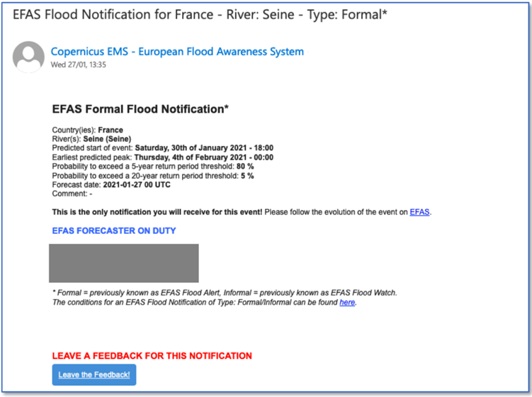
EFAS flood notifications contain an indication of the potentially affected larger region or river/tributary section and a very short and basic information on the predicted probabilities to exceed a certain flood return period. Furthermore, there is an advisory message to follow a link to access the more detailed, regularly updated flood forecast information displayed in the EFAS map viewer. An example of a typical flood notification is shown below:
Why are EFAS notification so short?
The EFAS notifications do not aim at summarizing all the detail of an EFAS forecast. Instead, they aim to raise the awareness about the risk of an upcoming flood in a specific river section and invite the EFAS partner to look at all the forecast details in the EFAS map viewer.
What additional information can be provided once the notification has been received? Where to search for it?
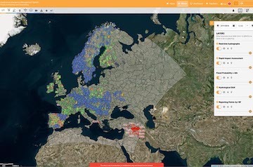
EFAS partners are invited to look at the detailed forecasts in the EFAS map viewer, where the expert user can find a broad range of different indicators and products that help the user in evaluating the forecast such as flood probabilities, model initial conditions, precipitation forecasts or the model performance for the specific river basin.
What are the usual next steps after EFAS has sent a flood notification?
Once an EFAS notification has been received, the relevant national authority is advised to connect to the EFAS map viewer for a more detailed forecast information, and to analyse the situation together with the available national or local early warning information, to decide on the next actions.
Who receives EFAS flood notifications?
EFAS flood notifications are sent out to all the “EFAS partners” (see here for a list of EFAS partners and here for a definition of who can become an EFAS partner) in the potentially affected river basin. They are also send to the European Response and Coordination Centre (ERCC), the heart of the EU Civil Protection Mechanism, in order to create early awareness on the high risk of flooding in the coming days. In the case of trans-national river basins, EFAS notifications are also shared with national authorities that might not be immediately affected by the forecasted flood (e.g. EFAS notifications for the German section of the Rhine are always also shared with the relevant Dutch, Belgian and Swiss authorities). EFAS notifications related to flash floods are only sent to the relevant national or regional authority.
Are EFAS flood notifications available to the public?
EFAS notifications are not aimed at warning the public as the notifications contain expert information that should be combined with the relevant available national and local information to provide the best possible basis for decision making. To respect the national competence for warnings and the single-one-voice warning principle, EFAS Flood notifications and other related forecast information are not shared publicly.
Archived EFAS forecast data including an overview of EFAS flood notifications are available here. A list of all flood notifications indicating the river section or region, the lead time, the forecast date and the main affected country are publicly available after 30 days in the regularly published EFAS bulletins. (see example here)
Are EFAS Flood Notifications without any obligation?
Yes. EFAS notifications aim at providing complementary forecast information. The relevant national authority may or may not use the provided forecast information and is likely to also take into account other information in deciding on any measures to be taken.
Does EFAS monitor what is being done after the notification has been issued?
EFAS monitors the flood situation but does not monitor actions taken by national authorities based on EFAS flood forecast information or national warning system information, as such actions fall outside EU competence.
Does EFAS request acknowledgement of receipt from the relevant authorities once a notification has been received?
Partners who receive an EFAS Flood notification are not requested to send acknowledgement of receipt. In a flood situation, forecasting and emergency response authorities are extremely busy with processing and integrating all relevant information coming from a variety of sources and usually only reply to notifications if further questions arise. Regular feedback on EFAS flood notifications is requested in the aftermath of an event to continuously adapt and improve the system.
Other Questions:
What other services relevant for flood risk management are available under CEMS?
The rapid mapping component of the Copernicus Emergency Management Service (CEMS) provides mapping products based on satellite imagery and is usually activated for a certain area by an authorised user (typically regional/national authority responsible for civil protection). All CEMS mapping products can be found here.
Do satellite images help in forecasting floods or do they only serve coordination efforts?
Flood forecasting systems such as EFAS require model data (weather forecasts), satellite (e.g. land use, digital elevation, etc.) and in-situ data to model and predict floods. Satellite based flood extent maps can support the coordination and response to ongoing floods.
Who is responsible for preventing, preparing and responding to natural and man-made disasters in EU Member States?
The primary responsibility for preventing, preparing for (including early warning and public warning), and responding to natural and man-made disasters lies with the Member States.
On what basis is the European Commission supporting Member States in the field of early warning?
Art. 8 (c) of the of the Regulation 2021/836 amending Decision No 1313/2013/EU on a Union Civil Protection Mechanism (UCPM) has attributed a mandate to the European Commission in the field of EWS to complement and support the work of the Member States developing, e.g. transnational detection and early warning systems, such as the European Flood Awareness System (EFAS), mainly for transboundary floods.