Hydrological situation for February 2021
by EFAS Hydrological Data Collection Centre
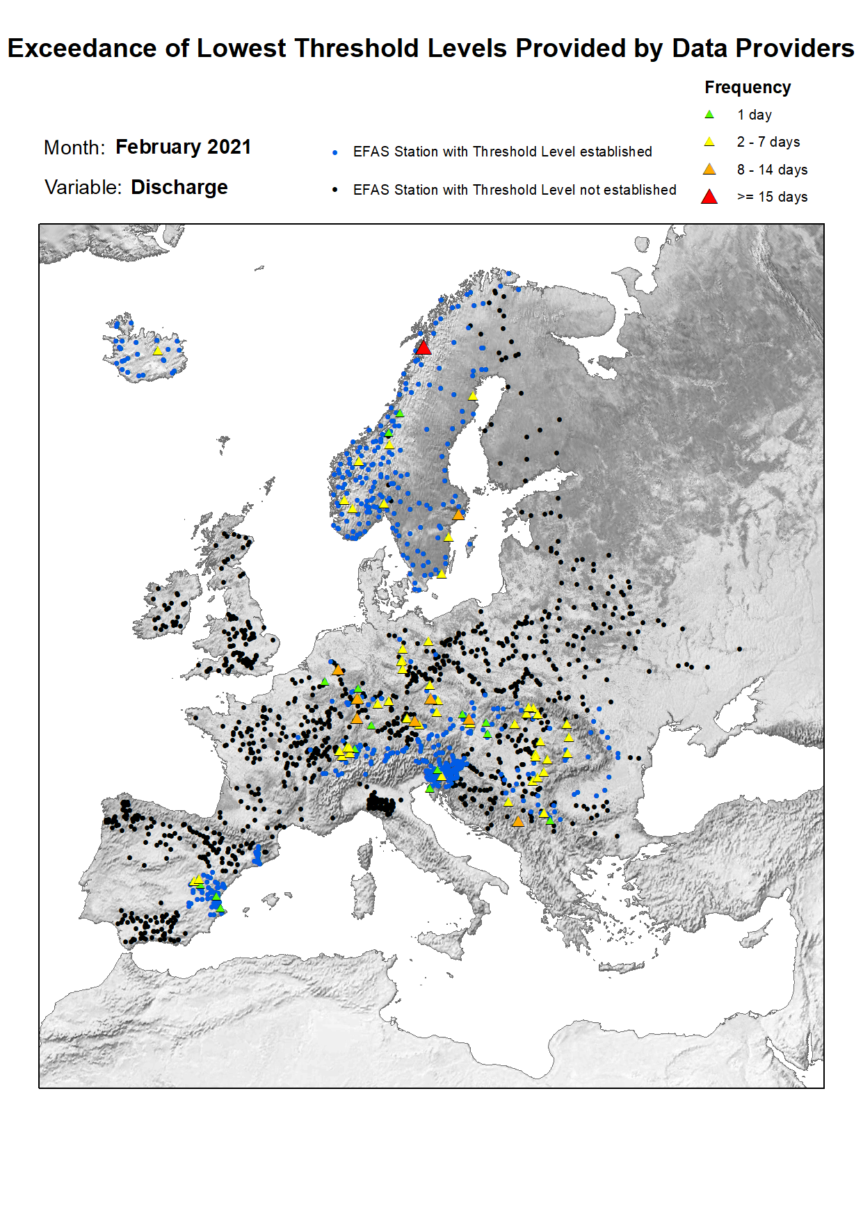
In February the hydrological situation was very similar to January with abundant rain that caused exceedances in a high number of stations, especially in central Europe. 263 stations registered exceedances in January, but this number increased to 297 in February. The affected basins and countries continue as they were in January. According to the number of stations affected, the Danube basin stands out again with 122 stations having values over their thresholds, which corresponds with the 22% of the stations located in this basin. Countries affected within this basin are southern Germany, Romania, Serbia, Hungary, Bosnia & Herzegovina, Austria, Czech Republic, and Slovenia. Another region with remarkable exceedances was found in the Po river basin, which accounted for 20% of stations located on this basin (31 stations). The Rhine basin stands out in third place with 19% of its stations with exceedances (in Germany and Switzerland). Other affected basins with more dispersed stations are the Oder, Vistula, Elbe, and Dnieper river basins (affecting Poland, Czech Republic, Belarus, and Ukraine) and in Spain along the Minho, Guadiaro, Guadalhorce, and Velez river basins in the Mediterranean and Levante areas. Finally, scattered stations with exceedances appear in Norway, Sweden, and Iceland.
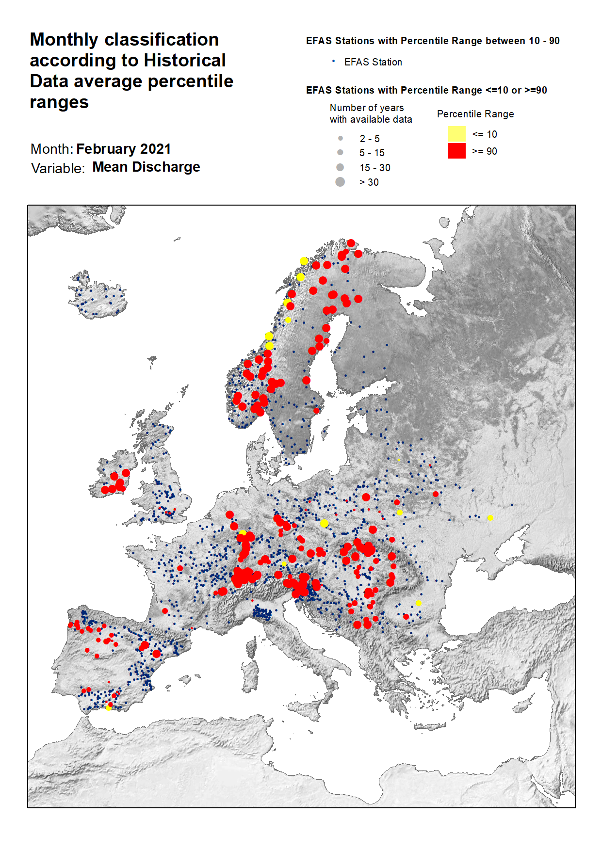
According to stations registering values above the 90% quantile, they are mostly located in central Europe. The Danube basin stands out with nearly 30% of the total stations exceeding the 90% quantile. Other basins registering a high concentration of stations are the Rhine and Elbe basins. To a minor extent in this area, stations also surpassing the 90% quantile are located in the Vistula, Oder, and Dnieper basins. Also, an isolated station on Dniester basin (Ukraine) surpassed the 90% quantile. Other high densities of stations can be found throughout the Spanish basins (Douro, Minho, Limia, Guadalquivir, and Ebro basins) and in the Scandinavian basins (mainly in southern Norway, followed by northern regions of Norway, Sweden and Finland with some scattered stations to the west of Sweden). To a minor extent, stations exceeding the 90% quantile can be observed in Ireland and the UK (all the stations in the Thames basin, England). Scattered stations surpassing the 90% quantile can be seen in France (four stations located in four different basins: Garonne, Rhône, Loire and Orb), two in the Rhone basin (Switzerland), one in the Soca/Isonzo basin (Slovenia), and the Po basin (Italy).
Lastly, regarding the stations registering values below the 10% quantile, the number has been reduced in February in contrast to the previous month. The highest concentration of stations is mainly found in central Norway, with six stations whose mean values are below the 10% quantile. In a more dispersed pattern, we also find a total of seven stations in the Danube basin (Germany and Romania), Dnieper basin (Ukraine), Rhine basin (Germany), Oder basin (Poland), and the Neman basin (Belarus). Finally, an isolated station also showing values below the 10% quantile is located in the Verde river in southern Spain.
